 |
|||||||||||||||
|
|||||||||||||||
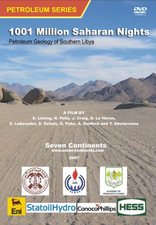
Order InformationThe documentary training film series about the petroleum geology of southern Libya is available through the Geological Society of London Online Bookshop. |


| Film 1 | Introduction |
| Geological Framework | |
| Pan-African Orogeny | |
| Infracambrian | |
| Film 2 | Upper Cambrian to middle Ordovician |
| Upper Ordovician glacial reservoirs, part 1 | |
| Film 3 | Upper Ordovician glacial reservoirs, part 2 |
| Discovery of the Elephant Oil Field | |
| Film 4 | Silurian source rock |
| Exploration History of southern Libya | |
| Film 5 | Silurian deltaic progradation |
| Devonian uplift and fluvial sands | |
| Middle Devonian to Carboniferous shallow marine cycles | |
| Film 6 | Mesozoic rifting and extension |
| Mesozoic continental deposits | |
| Alpine Uplift | |
| Tertiary Volcanism | |
| Meteorite Impacts | |
| Film 7 | Pleistocene-Holocene Wet Times |
| Hydrogeology | |
| Conclusions and remaining prospectivity |
The full documentary movie is now online on youtube, free of charge.
Film 1:
Film 2:
Film 3:
Film 4:
Film 5:
Film 6:
Film 7:
Credits:
A large selection of geological field photographs from Southern Libya has been uploaded into a dedicated flickr online photo album. To retrieve the full-resolution pictures, click on the photo in the overview, and on the next screen click the "all sizes" button. Feel free to use these pictures in your exploration presentations and research projects, but please reference the respective author mentioned in the photograph's caption or the seven-continents.com website as a source. We thank all colleagues who allowed us to present their photographs on this platform, in particular Karsten Battermann, Rolf Bortz, Steve Schulz, Stefan Lubeseder, Gregg Pyke and Mike Martin.
The non-profit film project is produced by 7C Science Productions, in co-operation with the Earth Science Society of Libya and the Academy of Graduate Studies (Tripoli). The film's script has been written by Dr Sebastian Lüning who also did all of the desert filming as well as the film editing. Co-authors in this production are Dr Nuri Fello, Dr Jonathan Craig, Daniel Le Heron, Yousef Abutarruma, Steve Schulz, Stefan Lubeseder, Gregg Pyke and Andre Dunford. Earlier film productions of 7C include a training video about the Silurian hot shale of SW Libya and the movie Natural Wonders of the Maghreb Expedition through Morocco's Earth History, a format for the general public.
Fieldwork of some of the authors in southern Libya was supported by the North Africa Research Group, CASP, Woodside, and Oxy.
Parts of the film have been shown at the PESGB/HGS Africa Conferences 2006 (London) and 2007 (Capetown) as well as at the Geological Society Infracambrian Conference 2006 (London).
"At the end of the day we were given a real treat, the first public screening of a film, the 'Petroleum Geology of Southern Libya', a movie directed by Sebastian Lüning from the University of Bremen. It included stunning scenescapes, close-ups of outcrops, plate reconstructions and seismic examples. If you only see one movie this year we suggest you make it the blockbuster offering from Lüning!"
(Kevin Dale and Stuart Munday, Newsletter of the PESGB, November 2006 issue, p. 85).
Dr Hussein Seddiq (NOC, Tripoli)
Abdallah Khoja (NOC, Tripoli)
Prof. E. Klitzsch
(Technical University of Berlin)
Dr Jonathan Craig (Chief Geologist, Eni)
Dr Daniel Le Heron (University of Hanover, formerly CASP)
Dr Nuri Fello (Repsol Oil Operations and Academy of Graduate Studies, Tripoli)
Dr Abdussalam A. Aziz (Repsol Oil Operation)
Fateh A. Belhadj (Tripoli)
David Boote (Consultant Geologist, London)
Dr Simon Beswetherick (Eni, London)
Bashir Meijrab (Shell, formerly Lasmo)
Dr Frank Lisker (University of Bremen)
Dr Sebastian Lüning (Consultant Geologist, Bremen)
Prof. Adolf Seilacher (Yale and Tübingen University)
Vince Whithams (Eni, formerly Lasmo)
Geological Evolution of southern Libya
Due to the arid climate, Palaeozoic outcrops in southern Libya are widespread and often spectacular. In many cases economically important horizons from the subsurface can be studied in greater detail in surface exposures. The visualisation of these topics in a popular video format is believed to help geologists and non-geologists to better understand the basic principles of the southern Libyan geology and by this increase efficiency of their activities in the region. An introduction to field outcrops is particularly needed, as only few geologist may get the chance to visit these sites themselves. For some geologists the standard wireline log "wiggles" may suddenly turn into something more meaningful, enhancing their geological creativity.
|
|
|
 |
 |
|
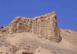
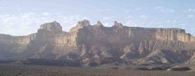
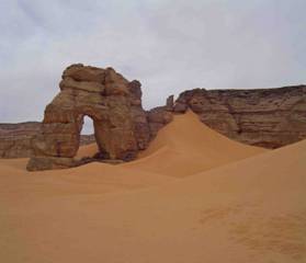
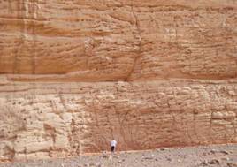
| Erosional arch in the Tadrart Fm. In the Akakus Mountains | Braided river Tadrart sandstones (early Devonian, Ghat Oucrop Belt) |
The documentary training film series about the petroleum geology of southern Libya is available through the Geological Society of London Online Bookshop.
|
| © 7C |